precision mapping for safer marine operations

Jump to
Expertise
Fugro’s hydrographic surveys provide high-accuracy bathymetric data and seafloor mapping solutions, supporting industries such as offshore energy, maritime navigation, and coastal engineering. Using advanced multibeam echosounders, bathymetric lidar, and seismic survey vessels, we deliver precise hydrography data for informed decision-making.

Marco Filippone
Global lead - Hydrographic surveys
Comprehensive Hydrographic Surveying Services:
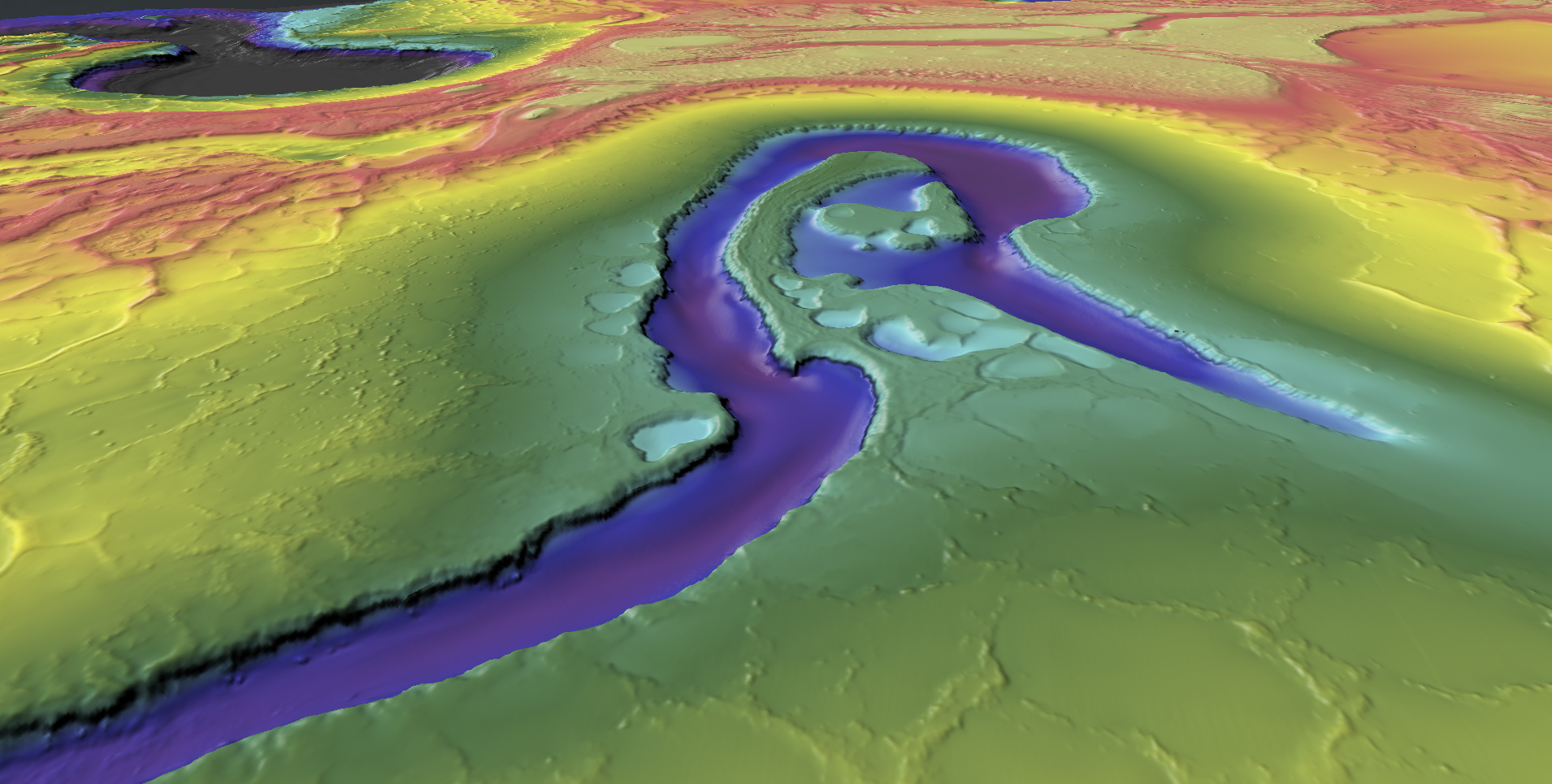
Bathymetric Surveys and Seafloor Mapping
Our bathymetric surveys offer high-resolution ocean floor maps, aiding in marine infrastructure projects, dredging operations, and environmental monitoring. With bathymetric lidar and multibeam sonar, we capture detailed bathymetry maps to assess underwater terrain.
Hydrographic Engineering and Offshore Surveys
We support complex offshore survey requirements, from seismic survey vessel operations to hydrographic engineering for subsea infrastructure. Our hydrological surveys also provide critical insights for coastal resilience and flood risk assessment.
Marine Mapping and Coastal Management
Using seafloor mapping technologies, we help clients map the seabed, supporting applications like port development, offshore wind farm planning, and subsea cable routing. Our topographical land survey services further enhance coastal and land mapping accuracy.
Understanding Hydrographic Surveys: Methods, Importance, and Accuracy
What is a hydrographic survey?
A hydrographic survey measures and studies underwater features and activities. This includes tasks such as navigating ships, marine construction, removing silt from the bottom of water bodies, setting up wind farms at sea, and exploring and drilling for offshore oil.
We offer services such as measuring water depth using light detection (lidar bathymetry), using sound waves to map underwater areas (acoustic surveys), and analysing satellite images. Our clients, which include both government agencies and private companies, use these services for creating detailed maps for navigation, planning routes for underwater cables, and coastal zone management.
Our expert team provides highly accurate maps and data, offering valuable insights and efficient solutions for your projects with our advanced technologies.
Why are hydrographic surveys important?
Hydrographic surveys are important for a variety of reasons, which affect a range of industries and requirements.
Hydrographic surveys ensure safe navigation by providing accurate depth information of water bodies so when planning routs ships can make decisions on the safest route. They also support activities like port maintenance, coastal engineering, offshore oil exploration, and offshore resource development as well as supporting environmental protection and health to ensure the protection of our all important ecosystems.
This type of survey plays a vital role in the global economy by supporting maritime infrastructure like ports, docks, navigational aids, offshore platforms, and terminals where goods and people are transferred.
What is a multibeam bathymetric (MBES) survey?
A multibeam bathymetric survey is a method used to map the underwater terrain of bodies of water. This survey is also known as an MBES survey.
This method uses a multibeam echosounder. Which uses sound waves in a fan shape to calculate the water depth and looks at the ‘solidness’ of the sea floor. We use MBES surveys as they can be faster to conduct and provide a more accurate picture for your business. MBES surveys are also crucial for offshore wind farm development, providing detailed maps that ensure the safe and efficient installation of wind turbines.
These sound waves travel through the water and bounce back (echo) when they hit the seafloor or any underwater object. The time it takes for each sound wave to return is measured, which helps determine the distance to the seafloor. The multiple beams cover a wide area, allowing for detailed mapping in a single pass. We can create a 3D map of what is under the ocean floor to show the underwater landscape clearly, helping you understand the underwater landscape better.
How long does a hydrographic survey take?
The duration of a hydrographic survey depends on several factors, including the survey area size, water depth, environmental conditions, and the technology used.
For small-scale surveys, such as port or harbour assessments, data collection may take a few hours to a couple of days. For larger offshore projects, such as seabed mapping for offshore wind farms, subsea cable routes, or oil and gas exploration, surveys can take several weeks to months.
Post-survey, the processing and analysis of hydrographic data can take additional time, ranging from a few days to several weeks, depending on the amount of data collected and the level of detail required.
What is the difference between hydrographic and bathymetric surveys?
“Bathymetric” and “Hydrographic” are both methods to map underwater areas (marine topography), but there is a difference between the two surveys. While closely related, these methods serve distinct purposes in mapping and exploring the underwater landscape.
We use a bathymetry survey to map the underwater landform shape and depth of the seabed. Bathymetric maps are like topographic maps, but for underwater landscapes. They use colours and lines to show different depths of the ocean floor. Bathymetric maps are also used for planning the routes of underwater cables, ensuring they are laid in the safest and most efficient manner.
Hydrography is the science of measuring and characterising bodies of water and their surrounding environments. Hydrographic surveys give a detailed view of the water column, including ocean depths, shorelines, and water composition.
What bathymetric equipment is used for surveying?
Bathymetric surveying relies on a variety of advanced equipment to accurately measure water depths and map the ocean floor. Key tools include multibeam echosounders, which emit sound waves in a fan shape to create detailed maps of the underwater terrain. These echosounders are often mounted on survey vessels and provide comprehensive data sets in a single pass.
Another essential tool is bathymetric lidar which uses light detection and ranging to measure water depths from the air. This technology is particularly useful for mapping shallow coastal areas and can penetrate clear water to provide high-resolution bathymetric data.
Satellite-derived bathymetry is also employed, using satellite images to estimate water depths and create bathymetric maps over large areas.
This equipment is crucial for applications such as marine construction, offshore wind farm planning, and safe navigation by providing detailed insights into the underwater landscape.
How accurate is bathymetry?
The accuracy of bathymetry depends on the survey method used, environmental conditions, and the required level of precision.
MBES are among the most precise technologies, achieving accuracy within ±0.1% of the water depth. For example, in 100 metres of water, the depth measurement would typically be accurate to within 10 centimetres. Bathymetric lidar is another advanced technique, capable of delivering accuracy between 15 to 30 centimetres in optimal conditions, though its effectiveness decreases in turbid or deep waters. Satellite-derived bathymetry, while useful for large-scale mapping, generally has lower accuracy, ranging from one meter to several meters, depending on water clarity and calibration.

Benefits
High-quality data
Captured by a full array of leading-edge sensors with extensive coverage
Sustainable operations
Using advanced techniques and technologies to reduce your projects carbon footprint by up to 90 %
Improve HSSE
Through the use of remote and autonomous technologies revolutionising the way we undertake our surveys
Efficient project life cycle
Access to essential insights will reduce costs, speed up your project schedule and minimise risk for your project
Key figures
km2 of bathymetric data
Fugro has contributed to the Nippon Foundation-GEBCO Seabed 2030 initiative
Related news


Contact us
Get in touch for hydrographic surveys

Marco Filippone
Global lead - Hydrographic surveys

Fugro Academy Training Centre
Applied Hydrographic Survey Programme
Our internationally recognised International Hydrographic Organization (IHO) Category B programme is designed to help you build skills in the science and technology of hydrography and move forward in your career.